ROAD NETWORK OF PAKISTAN
No matter how advanced the railways or air services are, roads continue to be the prime source of major traffic around the world. The same holds true in case of Pakistan as well. Although, the condition of road network is not comparable with those of developed countries, but in the region, these are said to be quite adequate despite bumps and cracks. In the past 20 years, there has been a major stress on development of the road infrastructure. The first major highway of any consequence was the Super Highway that was build in President Ayub's era, joining Karachi and Hyderabad in the Sind Province. Then a major break through came when the Karakoram Highway was constructed with the assistance of China, connecting Pakistan and China through one of the most rugged mountains of the world. At Khunjrab Top, the road rose to be the highest in the world. Then came the motorway ear in the 90s when Lahore-Islamabad motorway was completed with the assistance and technical expertise of the Koreans. Since then, motorway netwqrk has extended to Peshawar, Faisalabad and plans are under way to connect Multan and Karachi.
In other words, road transport is the backbone of Pakistan's transport system. The 9,574 km long National Highway and Motorway network - which is 3.65 percent of the total road network - carries 80 percent of Pakistan's total traffic. Over the past ten years, road traffic – both passenger and freight - has grown significantly faster than the national economy. Currently, it is accounting for 91 percent of national passenger traffic and 96 percent of freight. However, over half the national highways network is in poor condition, and the road safety record is poor. The country’s truck fleet is mostly made up of obsolete, underpowered, and polluting vehicles, and trucks are often grossly overloaded. Truck operating speeds on the main corridors are only 40 – 50 kph for container traffic, half of the truck speeds in Europe. For trucks carrying bulk cargoes, the journeys take 3-4 times longer than in Europe.
 The
Karakoram Highway: The
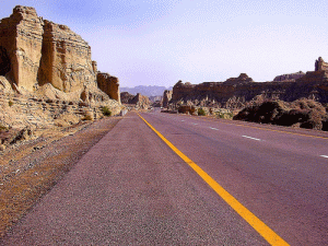
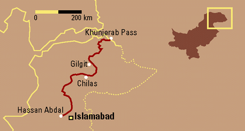
1300 kilometres (800 miles) long KKH, or the N-5, originates from Hassan
Abdal, a place some 45 kilometres from Islamabad on the Islamabad - Peshawar
Highway, goes through Abbotabad, Manshera, crosses the River Indus at Thakot,
on to Gilgit (through Besham, Pattan and Sazin) and then to Chilas, Hunza and Sost before crossing the Khunjerab Pass at the
height of some 4800 metres (15,750ft) - the Zero Point between Pakistan and
China. It then enters the high Central Asian plateau before winding down
through the Pamirs to Kashgar, at the western edge of the Taklamakan Desert.
It is a marvel of human endurance, ingenuity and determination. Both
Pakistani and Chinese workers and engineers worked day and night over some
of the most formidable and inaccessible mountain ranges of the world, with
deep gorges and torrential Indus running along the track with its full
might. The Indus River flows northwest, dividing the Himalaya from the Karakoram.
The KKH runs along the Indus for 310 kilometres of its climb north, winding
around the foot of Nanga Parbat, the ninth highest mountain in the world.
Not far north of Jaglot the Gilgit river joins the Indus from the west. The
highway then leaves the Indus for Gilgit, Hunza and Khunjrab rivers to take
on the Karakoram Range - where 12 of the 30 highest mountains in the world
overlook the KKH. At Khunjrab Pass, the KKH proudly stands as the highest
metalled border crossing in the world.
En route to Khunjrab, before Gilgit, there is a road sign inviting the attention of the tourists to stop and see the the Hindu Kush mountains converge with the Karakoram Range, a part of the Himalayan mountain system.
While traveling along the KKH, many a tourist wonder as to how the
Pakistanis and Chinese ever get this road through? Since the road has been
carved through a tectonic collision zone and still generally kept open.
Read
more ...
The
Karakoram Highway: The
1300 kilometres (800 miles) long KKH, or the N-5, originates from Hassan
Abdal, a place some 45 kilometres from Islamabad on the Islamabad - Peshawar
Highway, goes through Abbotabad, Manshera, crosses the River Indus at Thakot,
on to Gilgit (through Besham, Pattan and Sazin) and then to Chilas, Hunza and Sost before crossing the Khunjerab Pass at the
height of some 4800 metres (15,750ft) - the Zero Point between Pakistan and
China. It then enters the high Central Asian plateau before winding down
through the Pamirs to Kashgar, at the western edge of the Taklamakan Desert.
It is a marvel of human endurance, ingenuity and determination. Both
Pakistani and Chinese workers and engineers worked day and night over some
of the most formidable and inaccessible mountain ranges of the world, with
deep gorges and torrential Indus running along the track with its full
might. The Indus River flows northwest, dividing the Himalaya from the Karakoram.
The KKH runs along the Indus for 310 kilometres of its climb north, winding
around the foot of Nanga Parbat, the ninth highest mountain in the world.
Not far north of Jaglot the Gilgit river joins the Indus from the west. The
highway then leaves the Indus for Gilgit, Hunza and Khunjrab rivers to take
on the Karakoram Range - where 12 of the 30 highest mountains in the world
overlook the KKH. At Khunjrab Pass, the KKH proudly stands as the highest
metalled border crossing in the world.
En route to Khunjrab, before Gilgit, there is a road sign inviting the attention of the tourists to stop and see the the Hindu Kush mountains converge with the Karakoram Range, a part of the Himalayan mountain system.
While traveling along the KKH, many a tourist wonder as to how the
Pakistanis and Chinese ever get this road through? Since the road has been
carved through a tectonic collision zone and still generally kept open.
Read
more ...
Makran Coastal Highway
The
construction of Gwadar port would have been be meaningless if it were not
linked with a highway with Karachi - the main business centre of Pakistan.
Therefore, it was decided to construct a Coastal Highway linking Karachi
with Gwadar some 675 kilometres in length. The highway has since been
completed by the Frontier Works Organization of Pakistan Army Engineers and
is considered to be a marvel of technology and human determination.
Concurrently highways, from Pasni to Gwadar (135km), Ormarah - Gwadar (275km)
and Gwadar -Turbat (188 km) are also being built to support the main
highway. The horizontal links will ultimately be built up for a south -
north link through the Indus Highway to China.
Under an agreement, Pakistan, China,
Kazakhstan, Kyrgyzstan and Uzbekistan are already committed to developing
extensive railroad links from Central Asia and the Chinese province of
Sinkiang to the Arabian Sea Coast. The completion of this communication
network will facilitate movement of goods from China and CARs to the
countries of the Persian Gulf, West Asia, East Africa, the Indian Ocean
through Gwadar.
Besides the road network, there are plans to set up an international airport
equipped with all modern aviation facilities, including runways to handle
landing of wide-bodied 747 aircraft.
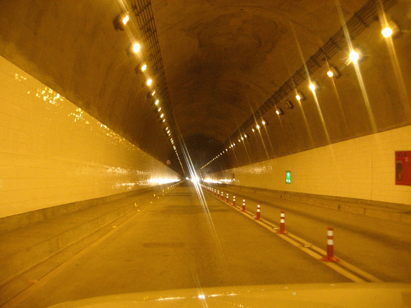
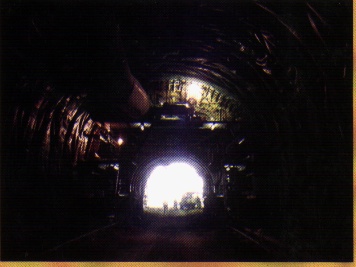
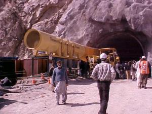
Kohat Road Tunnel: Smooth flow of traffic in the rugged mountains of north of Pakistan has always been a problem. About 10 km northeast of Kohat city, Bosti Khel mountains intercept smooth traffic flow and the traffic had to pass over rugged mountains, making it hazardous and time consuming as well. There there was a need for a tunnel to circumvent the traffic congestion. The mountain range at Bostikhel has extremely complex geology. Intensive geotechnical studies, therefore, were undertaken prior to initiation of the tunnel project. These studies included geophysical exploration and other survey techniques. After execution of the survey project a study was undertaken at National University of Sciences & Technology, Risalpur Campus, to determine success/failure of the techniques used for predicting tunnel geology. After detailed survey, the project of the tunnel was finalized with the assistance of Japan and Japanese standard was adopted in the tunnel design as well as execution.
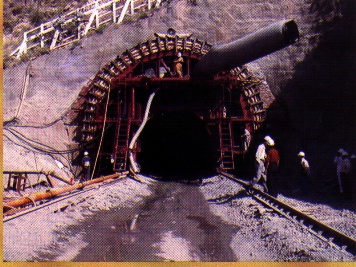
Making and Opening of the Tunnel
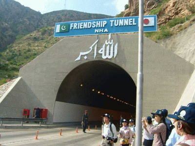
The tunnel is about 1.9 kilometres long and its construction began in 1999, and was opened to the public in June 2003. As part of the developing Indus Highway system, the tunnel serves as a shorter, alternate route to the Kohat Pass, situated between the cities of Peshawar and Kohat. The new route decreases the time required to travel through the Kohat Pass from three hours to less than one hour. Also, the tunnel will enable the passage of large vehicles, alleviate traffic congestion, improve traffic safety, and promote economic development. Since it has been built with the active involvement of the Japanese government, it is also referred to as the "Friendship Tunnel". Recently, the Pakistan Postage issued a commemorative stamp for the celebration of 50 years Pak-Japan friendship, showing Kohat Tunnel as one of the biggest projects ever undertaken by Japan in Pakistan.
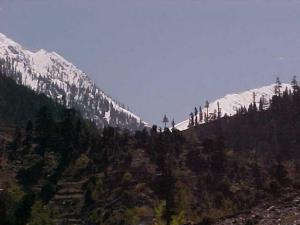
Lowari Tunnel Project: Chitral - the land of Shandur and the Kafirs is located beyond a very difficult mountain top, the Lowari Top at 10,230 feet, which makes it almost inaccessible to reach Chitral for good about six months in winters, from late November to late May every year, due to snow fall. In winters, one has to enter Afghanistan from down Kunar River and then re-enter Pakistan to evade the snow covered top. Thus the only link with Chitral is through air. Therefore, a plan to build a tunnel cutting through its way from the Lowari Pass was conceived in the 1970s. The work began on the 8.8 kilometers long tunnel in 1977 but was then stopped at just 100 feet for paucity of funds and lack of sponsors from abroad. With the building of the tunnel, the 12-14 hours journey from Peshawar to Chitral is not only likely to be reduced to half but would also ensure a safe and open passage to Chitral throughout the year. The tunnel also serves strategic purposes, both economically and militarily.
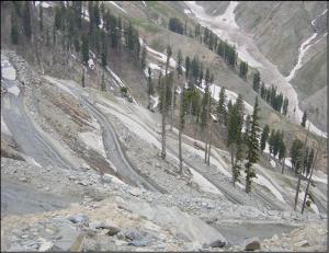
Left to Right: Lowari Top - The treacherous Zigzagged way to Lowari - The abandoned work
The plans for the revival of the tunnel work have recently been undertaken by the government of Pakistan and a South Korean company has been assigned the work on the tunnel, which is scheduled to start in October 2006. It is expected to be completed in three years at a cost of Rs.8 billion ($133 million US). It will be Asia’s largest tunnel, according to local media reports. Lately there has been a revision in the plan and now instead of a road, a railway link will be established through the tunnel as a wide road will cost much more than simply a railway line.
Some of the other major highways which have either been completed or are under construction are:
The N-5: N-5 carries 60 % of entire traffic of the
country. It is the life line of Pakistan. 80 % of economic activity is being
carried out through it. N-5 is the longest Highway having length 1756 Km. It
connects Karachi to Torkham via Multan, Lahore, Rawalpindi and Peshawar.
Indus Highway:
Indus Highway is vital not only for defense of the country but also to open up
West Bank of river Indus to greater economic activity. This project was
conceived in early seventies but was abandoned in 1978. The Government is now
giving higher priority to this project. Under Phase I & II, work on ten
contracts covering a length of 823 kilometers of the Highway has been awarded.
Under Phase III, remaining sections covering about 400 km and Kohat Tunnel will
be taken up. Loan negotiations with OECF of Japan for Kohat Tunnel have been
finalized. Contracts for these works will be awarded during 1994.
Karachi Khuzdar-Quetta Chamman Road:
To materialize higher priority to infrastructure in Balochistan, the Government
has provided larger funds to this project. Apart from benefiting the people of
the province, this road provides the shortest route for Karachi port to Central
Asian States. At present, it is a narrow road of low specifications. To cater
for the heavy traffic, widening and improvement of this road has been taken up
by the Government. Work on 308 km costing Rs. 2.77 billion has already been
awarded.
Quetta-Dalbandin-Naukundi-Taftan Road:
This road which provides the main link to Iran is narrow and of low
specifications. The Government has accorded top priority to this project. The
missing link between Nankundi and Taftan (124 km) has been completed.
Improvement of 168 km of road between Dalbandin-Nankundi costing Rs. 1986
million is in hand.
Ratodero-Khuzdar Expressway:
Contract for the construction of Ratodero-Shahdadkot-Quba Said Khan section (64
km) of the above Expressway has been awarded. The work is in progress. This
Expressway will ultimately be linked with Gwadar Port. The feasibility study and
design work of Gwadar-Khuzdar section is also nearly complete. This Expressway
will provide a direct access to the port of Gwadar for Balochistan, Sindh and
Punjab provinces. With the construction of this modern highway, Central Asian
Republics will be able to use the deep-water port of Gwadar.
Sukkur Bridge and Bypass:
National Highway N-5 and N-65 are linked by the Sukkur Barrage Road Bridge which
is very narrow and not suitable for heavy traffic. In order to cater for the
increasing volume of traffic, a new bridge down-stream of the Barrage along with
Sukkur By-pass has been ordered at a cost of US $ 40 million. Negotiations are
at advanced stage with Asian Development Bank.
Tall-Parachiner Road: For the development of Federally Administrated Tribal Areas, the Government has accorded high priority to the completion of Tall-Parachinar road. Rs. 100 million have been allocated during 1994-95 for the completion of this road. The Prime Minister has also directed to extend this road upto Afghanistan border.
The Motorways:
|
Related Links: | Pakistan Highway Data | |
|
| HOME PAGE | AIR LINKS | PAKISTAN RAILWAYS | PORTS AND SEA LINKS | TELECOM | Copyright©JalalsPages - 2008 |