K2 - Chogori - Mt. Godwin Austen
The Savage Mountain
The Largest Pyramid on the Earth
 K-2, the second highest point
on earth, located in the Karakoram segment of the Himalayan Range. In 1958,
Fosco Mariani, the great Italian climber described the Karakoram as the
"World's Greatest Museum in Shape and Form." Standing
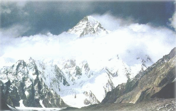
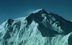
at 28,251 feet, K-2, the crown jewel of the Karakoram, is the world's second
highest peak. K2's imposing granite pyramid contains enough mass to fill
over 80 Matter horns. Many mountaineers consider K2 the most difficult and
dangerous 8,000 meter peak to climb. K2 takes second place only to Mount Everest more than 1,500
miles away. The summit of K2 lies on the border of China and Pakistan. On
its eastern side is Chinese Taxkorgan Tajik Autonomous County in Xinjiang
Province (formerly Chinese Turkestan); while on its west are the Northern
Areas of Pakistan. The local Balti people, who live on the Pakistan side,
call it "Chogori" meaning “Mother Mountain” in their Tibetan dialect. The
Chinese officially refer it to as Qogir or Qiaogeli Feng.
K-2, the second highest point
on earth, located in the Karakoram segment of the Himalayan Range. In 1958,
Fosco Mariani, the great Italian climber described the Karakoram as the
"World's Greatest Museum in Shape and Form." Standing
at 28,251 feet, K-2, the crown jewel of the Karakoram, is the world's second
highest peak. K2's imposing granite pyramid contains enough mass to fill
over 80 Matter horns. Many mountaineers consider K2 the most difficult and
dangerous 8,000 meter peak to climb. K2 takes second place only to Mount Everest more than 1,500
miles away. The summit of K2 lies on the border of China and Pakistan. On
its eastern side is Chinese Taxkorgan Tajik Autonomous County in Xinjiang
Province (formerly Chinese Turkestan); while on its west are the Northern
Areas of Pakistan. The local Balti people, who live on the Pakistan side,
call it "Chogori" meaning “Mother Mountain” in their Tibetan dialect. The
Chinese officially refer it to as Qogir or Qiaogeli Feng.
Initially this gigantic coned
shape mountain was known as the Mt Godwin Austen because the mountain was
first surveyed in 1856 by a European survey team headed by Henry Haversham
Godwin-Austen. Later a British officer T.G. Montgomery designated it K2 for
the second peak in the Karakoram Range - and
"K"
being the
the initial letter of the word Karakoram, the
titanic range of ancient granite to the west of the Himalayas that splits
the subcontinent from the Central Asia..
The other peaks of the Karakoram Range were named K2, K3, K4 and K5, but
eventually renamed Masherbraum, Broad Peak, Gasherbrum II and Gasherbrum I
respectively. These peaks represent some of the world’s highest summits.
 Chogori
- K2 or Mt Godwin Austen was first attempted in 1902,
but it was 52 years later when an Italian expedition scaled it successfully in
1954. Recently, in
2004, Pakistan celebrated the golden jubilee / 50th anniversary of its first
successful scaling and it was good to have the leader of the 1954 - Italian
Expedition visiting Pakistan and sharing experiences with many still wanting to
climb K-2.
Chogori
- K2 or Mt Godwin Austen was first attempted in 1902,
but it was 52 years later when an Italian expedition scaled it successfully in
1954. Recently, in
2004, Pakistan celebrated the golden jubilee / 50th anniversary of its first
successful scaling and it was good to have the leader of the 1954 - Italian
Expedition visiting Pakistan and sharing experiences with many still wanting to
climb K-2.
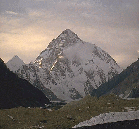
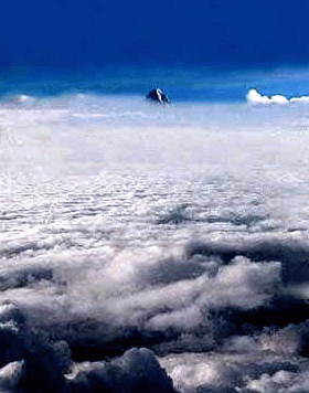
En route to Skardu, one can walk in to a friendly captain's cockpit to have a glimpse of the top of the K-2 pyramid in the far distance on the skyline.
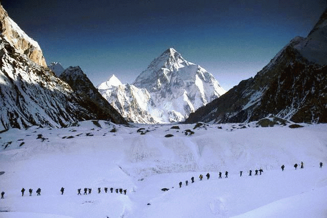
Below left is a picturesque view of the famous
base camp "Concordia"
- which serves as the final step towards the
deadly journey upwards to the giant
Killer Mountain
- as known by many a mountaineers who lost their comrades in an attempt to reach
atop the mighty K-2. See
Map - Skardu - Concordia and K-2 Base Camp.
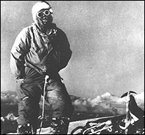
 31 July 1954
- 2004:
31 July 1954 was the day when at
6.00 pm two men finally conquered the summit of
the K2, the second highest mountain in the world, but certainly the most
challenging and feared. Lino Lacedelli
and Achille
Compagnoni climbed the 8,611 Metres high peak while Colonel M. Ataullah and Arshad Munir
accompanied the expedition from Karakoram Club of Pakistan. Captain (later Lt.
General) G.S. Butt was the liaison officer. In 2004, the 50th anniversary of
maiden climbing of K-2 was celebrated throughout the mountain climbers'
associations besides Italy and Pakistan. The 50th anniversary events, which took
place mainly between July 30 and August 1, included a scientific-mountaineering
expedition on K-2, the honorary leader of which was Minister Alemanno, the
inauguration of a K-2 museum in Skardu donated by Italy, the issuing of a K-2
postal stamp by the Government of Pakistan and an Italian-Pakistan polo match During the
celebrations, six Pakistani porters were drowned in a river while an Italian
expedition was attempting the K-2. To attend the celebrations, 78-year old Lino Lacedelli came to Pakistan and went to Skardu “to say hello and goodbye to
the king of mountains”. Lacedelli was accompanied by a 24-member team who held a
ceremony at base camp on July 15. Compagnoni, 89, lives in Italy, could not
attend the ceremony.
Read
More ....
(Map courtesy of Computer Terrain Mapping)
31 July 1954
- 2004:
31 July 1954 was the day when at
6.00 pm two men finally conquered the summit of
the K2, the second highest mountain in the world, but certainly the most
challenging and feared. Lino Lacedelli
and Achille
Compagnoni climbed the 8,611 Metres high peak while Colonel M. Ataullah and Arshad Munir
accompanied the expedition from Karakoram Club of Pakistan. Captain (later Lt.
General) G.S. Butt was the liaison officer. In 2004, the 50th anniversary of
maiden climbing of K-2 was celebrated throughout the mountain climbers'
associations besides Italy and Pakistan. The 50th anniversary events, which took
place mainly between July 30 and August 1, included a scientific-mountaineering
expedition on K-2, the honorary leader of which was Minister Alemanno, the
inauguration of a K-2 museum in Skardu donated by Italy, the issuing of a K-2
postal stamp by the Government of Pakistan and an Italian-Pakistan polo match During the
celebrations, six Pakistani porters were drowned in a river while an Italian
expedition was attempting the K-2. To attend the celebrations, 78-year old Lino Lacedelli came to Pakistan and went to Skardu “to say hello and goodbye to
the king of mountains”. Lacedelli was accompanied by a 24-member team who held a
ceremony at base camp on July 15. Compagnoni, 89, lives in Italy, could not
attend the ceremony.
Read
More ....
(Map courtesy of Computer Terrain Mapping)
Tips for those wishing to come close to Chogori or go atop it:
Need to obtain a climbing permit by applying to the ministry of tourism - which $ 12,000 for 7 climbers and around $2000 for extra climbers.
Next one needs to go to Skardu (located at 2,200 meters in Baltistan region of the Northern Areas of Pakistan). This can be done either by air or by road.
With luck and good weather, a 50-minute Boeing 727 flight over Nanga Parbat's dominant massif drops climbers in Skardu, at the Karakoram's doorstep.
Skardu is surrounded by 4,000 metres towering peaks - but this is just the beginning of some of the highest peaks of the world.
Here the group needs to hire porters, get food and rent a Jeep for the continued trip to Askole(3,050 Metres). The road which passes through Shigar Valley is seldom in good condition due to continuous land slides - but amid a spectacular landscape.
The trip takes around 6 to 12 hours depending on conditions.
From Askole onwards, you need to start walking.
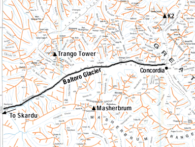
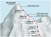
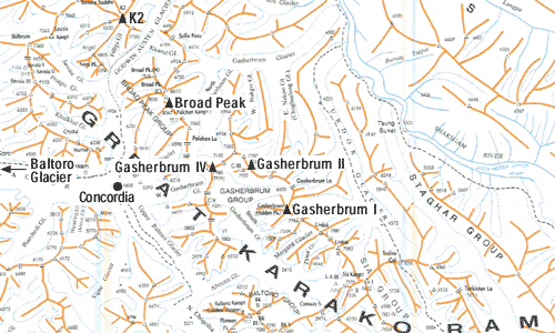
Maps (courtesy
mountainzone.com) - Baltoro Glacier (above) Gasherbrums (bottom) Next up is Juhla that
is 17 kilometers walk in difficult sand and rock terrain next to the
Braldu River and Biafo Glacier. The route continues to
Urdukas and Goro, where the climbers get to see the first glimpse of
famous 8,000 metres peak, Gasherburn IV - the Shinning Wall.
From here the route
continues to Concordia (4,650 metres) and to K2 Base Camp that is 10
km away from Concordia. Thereafter, it is one's
guts and determination till one reaches atop the "Chogori" - The
Savage Mountain.
Related Links:
| K2cimb.net
|
Women Climbers of K-2 and Nanga Parbat |
K2
at 50: The Bitter Legacy |
Recalling
Epic K2 First Ascent |
|
K2 Base Camp - Concordia Trek |
Karakoram'99 |
Pictures - Karakoram Mountains |
![]() 10 May 2006
10 May 2006
![]()
Copyright©JalalsPages - 2005