Chitral
Land of Tirich Mir and Kafir Kalash
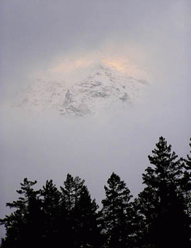
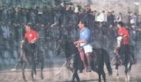
Ask anyone where Chitral is, and one may get a blank look since this land of Tirich Mir and the Kafirs, people of the lost world, is obscured behind the Lowari Top, which due to its inaccessibility generally keeps the tourist and holiday makers at bay. But those who dare to venture and reach out to Chitral Valley, find themselves in a different world - overlooked by the mighty Tirich Mir, standing at a height of 7,692 metres as part of the Hindu Kush mountain range, and located in the far reaches of Pakistan. Chitral is also famous for the Shandur Festival, which is held each year and where polo is played at the highest polo ground of the world at a height of 3,719 metres. The beauty of Chitral lies as much in its rustic, mountainous terrain, as in its warm hearted and friendly inhabitants. Since it is a land high up in the mountains, at such places legends fascinate the on lookers. One such legend describes Chitral as an abode of genies and fairies in times when no one lived here and locals still look up to the Tirich Mir, which they believe still has the castle of fairies.

Chitral forms Pakistan's north-western border with Afghanistan along the Hind Kush mountain range. The mountain passes that connect Afghanistan with Pakistan were the routes used by the Alexander the Great and his troops, who called the Hindu Kush "Parapamisus" meaning mountains over which no eagle can fly. After Alexander, Tartar hordes of Genghis Khan and Tamerlane also passed through, specially through the inaccessible Baroghil Pass (3,798 m or 12,460 ft) in the Upper Chitral (bordering the Wakhan Corridor of Afghanistan, which was once considered to be the rout to the famous Silk Route. Chitral has been traditionally and, except for a brief spell uninterruptedly, ruled by the Mehtars who claim themselves as ancestors the Tartar ruling family of Tamerlane.
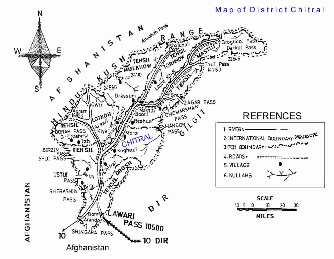
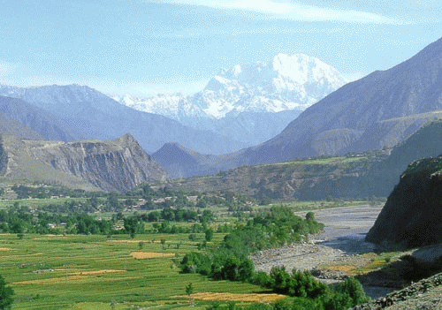
The 322 kilometres long Chitral Valley located at an elevation of 1,128 metres. The Chitral district has Afghanistan to its north, south and west. A narrow strip of Wakhan in the Afghan territory separates it from the erstwhile Soviet Union and present day Tajikistan. Chitral Town, capital of the Chitral District, is situated on the west bank of the Chitral (or Kunar) River, with an estimated population of some 20,000, while the Chitral District has a population of about 300,000.
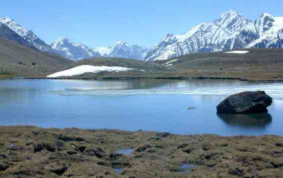
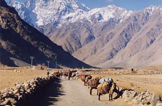
Broghil Lake - dividing Chitral and Ghizer Districts (left) - Shandur Pass (right)
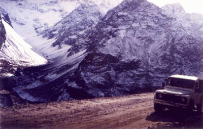
Being landlocked by mountain ranges, Chitral is only accessible through dozens of mountain passes, some of which are even more than 15,000 feet high. To the south, the dangerous jeep-able Lowari Pass (3,200 m or 10,499 ft) leads 365 kilometres to the region of Peshawar. In the north, the easiest route during summer (it is closed by snow in the winter), and the only one which allows the use of pack animals, runs over the Baroghil Pass (3,798 m or 12,460 ft) to Afghanistan's Wakhan Corridor. To the east, there is a 405 kilometres route to Gilgit over the 3,719 m (12,201 ft) Shandur Pass. And in the west, the Dorah Pass provides an additional route to Afghanistan. However, the easiest access to Chitral is in the southwest along the Chitral/Kunar valley towards Jalalabad (Afghanistan); this route is open all year and provides direct access to Kabul. However the Pakistan-Afghanistan border prevents this being used as an internal route to Peshawar and the south.
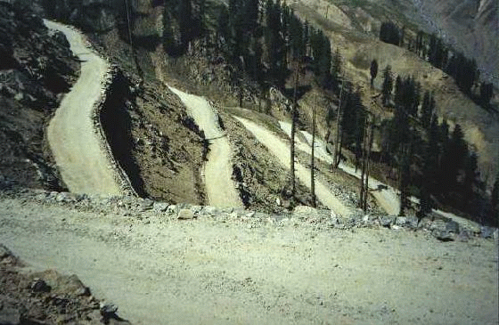
The Hair-Raising Lowari Twists - One should not venture to drive unless an expert mountain driver
|
|||||
Chitral's weather is as unpredictable as in any mountain valleys. The valley remains cut off from the mainland Pakistan due to heavy snow fall with temperatures falling below 0°C (32°F). Most of its precipitation originates from frontal cloud bands during the winter and heavy thunderstorms in the spring. The average rainfall is 414mm or 16.5 inches, while 350mm falls from December to May. At high elevations in the Hindu Kush, snowfall can be much heavier and consequently large glaciers are a prominent feature of the landscape. In view of its peculiar weather conditions, the ideal tourist season stretches from June to September. The maximum temperature in June is 35°C and the minimum is 19°C. In September, the maximum goes up to 24°C and the minimum temperature falls down to 8°C. The north, comprising Chitral District, has a typically continental steppe climate similar to Afghanistan and Tajikistan.
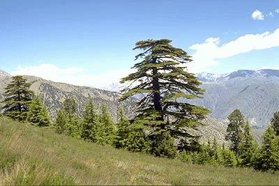
Chitral is rich in natural resources, fruits, trees and landscape. The aromatic cedar or deodar strewn on its landscape is a prize possession of Chitralis, which besides being burnt as fuel, is also used to make beautiful wood houses, furniture and coffins, following a tradition that dates back to the first Indus cities. "Chitrali Patti", a woolen cloth prepared from catted shu is one rarity and specialty of Chitral. Besides Finger Rings ( made up of animal horn ) are also very special.
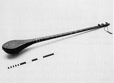 Besides, Chitral has a strong musical tradition.
The Chitrali Sitar is a long necked lute about 1 - 1.3 meter long with 5
strings tuned C-C-G-C-C. There are 12-13 frets. The player holds the 1st and
2nd strings together and play the melody. The rest of the strings play the
role of drone. The graceful sound of Chitrali Sitar is heard daily at small workingmen's teahouses in Chitral
Bazaar. The 'Shehnai' and 'Dol' (Oboe and Drums) frenetically accompany all
polo matches, specially at Shandur. Chitralis love to sing and dance. Any
Chitrali can sing and dance but professional musicians, generally forming a group of 8-10, perform during festivals. While one or two sing the verse
alternatively, the sitar player and a jerrican player add music and beat to it. The
rest will clap their hands and dance one by one.
Besides, Chitral has a strong musical tradition.
The Chitrali Sitar is a long necked lute about 1 - 1.3 meter long with 5
strings tuned C-C-G-C-C. There are 12-13 frets. The player holds the 1st and
2nd strings together and play the melody. The rest of the strings play the
role of drone. The graceful sound of Chitrali Sitar is heard daily at small workingmen's teahouses in Chitral
Bazaar. The 'Shehnai' and 'Dol' (Oboe and Drums) frenetically accompany all
polo matches, specially at Shandur. Chitralis love to sing and dance. Any
Chitrali can sing and dance but professional musicians, generally forming a group of 8-10, perform during festivals. While one or two sing the verse
alternatively, the sitar player and a jerrican player add music and beat to it. The
rest will clap their hands and dance one by one.
There are 10 languages which are indigenous to Chitral. The Norwegian linguist Georg Morgenstierne is of the opinion that Chitral was once the region with the highest linguistic diversity in the world. The reason for this is obvious. Chitral consists of high mountains interspaced by isolated valleys where small communities have thrived for centuries free from outside interference. The primary language of Chitral is Khowar ("kho" in local language is the name given to the natives of Chitral and "war" means language - the language of natives/Chitralis), which is the mother tongue of 90% of the population. Most of the remaining 10% speak Khowar as their second language. The other indigenous languages of Chitral, going clockwise around the Chitral Valley, are: Phalura, Gujari, Dameli, Gawar-Bati, Nuristani, Kalasha, Yidgha, Wakhi and Kirghiz. In addition, a variety of Persian is spoken in the isolated village of Madaglasht. All local languages, however, have no written form. Urdu being the national language of Pakistan is also spoken and understood.
It is customary in Chitral to offer the glass of water to as many people who are sitting around you before you drink it your self. It is also customary for you to get up whenever you see an apparently older person coming to join you. If you are in a group the whole group stands until the older person sits down or asks others to be seated.
|
|
 Historical
chronicles
reveal that in 2nd A.D Chitral was under the rule of a Buddhist ruler Jai
Paul, then the middle period is perceived to be ruled by
Kalash rulers, Rajawai, Bazik and Bula singh.
However, the Kalash suffered heavy casualties in a series of
skirmishes with the troops of Shah Nadir Rais, the
ruler of Rais Dynasty and finally concentrated in the Romboor, Bamborate, Birir
and Jinjirit (present Kalash valleys).
Historical
chronicles
reveal that in 2nd A.D Chitral was under the rule of a Buddhist ruler Jai
Paul, then the middle period is perceived to be ruled by
Kalash rulers, Rajawai, Bazik and Bula singh.
However, the Kalash suffered heavy casualties in a series of
skirmishes with the troops of Shah Nadir Rais, the
ruler of Rais Dynasty and finally concentrated in the Romboor, Bamborate, Birir
and Jinjirit (present Kalash valleys).
Then the Adamzadas came to throne and later on it is known as Katoor Dynasty
and still they are visible in shape of Royal family of Chitral. Chitral has been a
princely
state whose rulers decided to join Pakistan upon independence in 1947.
The ruling family of Chitral was the Katur dynasty, founded by Shah Katur
(1585-1630). During the reign of Mehtar Aman-ul-Mulk, known as Lot
(Great) Mehtar (Mehtar is a Turkish word meaning royal, king,elder), the dynasty's sway extended from Asmar in the Kunar Valley
of Afghanistan to Punyal in the Gilgit Valley. Tribes in Upper Swat, Dir
Kohistan and Kafiristan (present day Nuristan, not to be confused with the
Kalasha valleys which have always been an integral part of Chitral) paid
tribute to the Mehtar of Chitral. The ruler's title, Mehtar, is unique; his
male descendants were styled Mehtarjao, equally rare, until the higher
(Persian) royal style Shahzada, originally reserved for the Crown Prince (Tsik
mehtar, again unique, as Heir Persumptive, becoming Wali-Akht Sahib when
heir Apparent), was extended to all princes of the Mehtar's blood since the
rulers at that point. The scions of the Katur dynasty are still widely
respected and honoured by the people of Chitral today, but the current
Mehtar, H.H. Saif-ul-Mulk Nasir does not hold any royal powers.. During the
reign of Mehtar Aman-ul-Mulk, known as Lot (Great) Mehtar, the dynasty's
sway extended from Asmar in the Kunar Valley of Afghanistan to Punyal in the
Gilgit Valley. Tribes in Upper Swat, Dir Kohistan and Kafiristan (present
day Nuristan, not to be confused with the Kalasha valleys which have always
been an integral part of Chitral) paid tribute to the Mehtar of Chitral. The
ruler's title, Mehtar, is unique; his male descendants were styled Mehtarjao,
equally rare, until the higher (Persian) royal style Shahzada, originally
reserved for the Crown Prince (Tsik Mehtar, again unique, as Heir
Persumptive, becoming Wali-Akht Sahib when heir Apparent), was extended to
all princes of the Mehtar's blood since the rulers at that point.
|
A personal museum of one Mr Wazir on way up to Drosh fort has many interesting collections including one letter written by the British district political agent to the grand Mehtar stating that it has been observed with "concern" that locals do not get up and pay respect to the British when passing by on the road and that he is "advised" in his own interest to inform everyone that all locals to stand and pay respect to the passing by vehicles even if no British is sitting inside as mark of respect, lest the offender will be taken as a Russian spy and dealt with accordingly." |
The Mehtars dominated till the British, threatened by a possible Soviet invasion, established a garrison in Chitral in the 19th century. However, when these fears were ill founded, the British lost interest in Chitral, and the Mehtars were left to govern as they wished until the late 1960s, when the state was dissolved in 1969 and made part of Pakistan. However, the scions of the Katur dynasty are still widely respected and honoured by the people of Chitral today, however they do not hold any royal powers.
How to Reach Chitral:
By Air: The easiest way to Chitral is by air from Peshawar. PIA, the national airlines, operates daily Fokker flights to Chitral on subsidized rates. The flight takes 55 minutes but as is the case with all flights to the northern areas, this too is scheduled by the weather.
Helicopter Safari: There are number of tour operators who can arrange special helicopter safari to Chitral - Kalash Valley - Swat Valley.
By Road: For those who wan to see the beauty of the area right from Islamabad, the best way is to venture Chitral by road - 393 kilometres from Islamabad and 363 kilometres from Peshawar, which takes about 10-12 hours. From Islamabad or Peshawar, drive to Nowshehra and through Mardan and Dargai, go as far as But Khela. From here the road branches off to Swat and Chakdara. Take Chakdara route to Lower and Upper Dir and atop the 3,118 meters (10,230 feet) high Lowari Pass. Nearing the pass, the weather beaten road climbs up on the Dir side in wide loops and plunges into Chitral in about 50 sphincter tightening switchbacks. Clouds envelop the Lowari summit throughout the year. These are accompanied by high winds.
Snow blocks the pass from December to April. During this time, the Kunar road is the only way into Chitral. Opened in 1987, the road links Chitral and Kunar; it enters Afghanistan at Arandu. Running through the Afghan province of Kunar, it re-enters Pakistan through the Khyber Pass. The road remains open throughout the year, and its usage is made possible through an interim arrangement between the Chitral administration and Afghan authorities.
Places to Visit:

The Kalash Valleys of Bumburet, Birir and Rambur, for the peculiar lifestyle of its people which is a living image of what the European community once was in the medieval age. This may be because this pagan tribe was set apart from the world for centuries and had lost interaction with its inhabitants, thereby following their unique customs, culture, and religion since 400 BC. And till now, the history and background of this primitive tribe and its 3,000 people is still shrouded in mystery.
Sites of Gandhara Grave Culture (Proto historic Period) - The grave burials date back to era in between the Indus Valley Civilization and the arrival of Achaemenian in 600 B.C. These graves assume tourist and archeological attractions for the reason that Chitral has never been a part of ancient Gandhara.
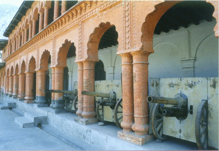
Forts and settlement sites of the 17th-19th centuries.
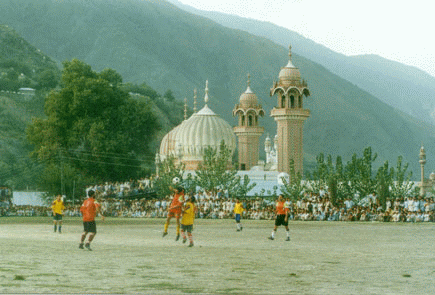
Bir Moghlasht, at an elevation of 2,743 meters (9,900 feet) and 15 km (9 miles) from Chitral, has the summer palace of the former Mehtar of Chitral. From the palace, one can get a good view of the river. The place also offers a spectacular view of Tirich Mir rising above and the valleys. A narrow winding road leads to the fort. Nearby is the Shahi Mosque of Chitral, was built by Mehtar Shuja-ul-Mulk about a century ago. It is a stylistic piece of architecture with its impressive inlays and decorations and its minarets and cupolas poised against a backdrop of a bleak, hilly landscape.
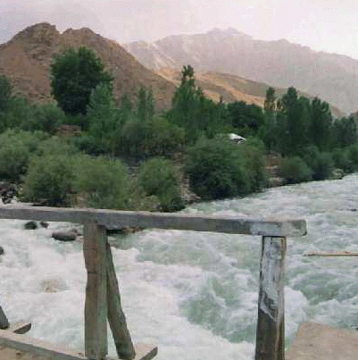
Garam Chashma (hot springs) is located 45 kilometres north west of Chitral at 1,859 meters. These springs (above right) have their source in the Hindu Kush mountains. A jeepable track takes takes 3 hours along the Ladakh River. Halfway through is the Shasha Pass, crossing it, the Ladakh and Shagor Rivers come into view, both flowing together into the Indus. The boiling Sulphur springs are famous for healing effect on skin diseases, gout, rheumatism and chronic headaches. For the convenience of tourists "hamams" (baths) have been constructed near the springs.
Chitral Gol National Park located in the north west of Chitral Town and is in the shape of a a huge mountain amphitheatre. Spread over an area of 7,750 hectares and established in 1984, the park has two hunting lodges, which were built by the Mehtars. The best time to go there is from May to September. Lammergier vulture, Himalayan Griffon vulture, Golden eagle, Demosille crane, Peregrine falcon, Himalayan snow cock, Himalayan monal, Snow partridge and rock Partridge are the most common birds found in the park. The park is also the habitat of markhor goats, the Siberian ibex, the snow leopard, the Ladakh urial (Shapu), the Tibetan Wolf, the Red fox, the Yellow throated martin, the Himalayan otter and the black bear.
Lakes of Chitral: There are four famous lakes in Chitral; Shandur Lake, Karbaza lake Chatti Bai Lake and Chiyan Tar lake. The first two lakes still exist while the other two have dried up. Lake Shandur is a beautiful spot on the border of Laspur Valley. Lake Karbaza is at Broghail in Yarkhoon Valley. Lake Chatti Bai is also in Broghail, but as mentioned earlier, it has dried up. Lake Chiyan Tar is another dried up lake in Lutkoh at Dorah Pass. Hot springs of brackish water force out their way at various places in Chitral, such as Lutkoh, Ambore, Treech, Boni, Shah Jinnali, Yarkhoon and Sindoor. People visit these in great numbers for the cure of skin diseases and asthma.
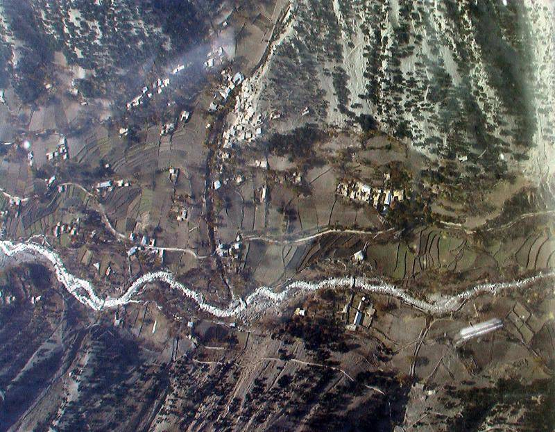
Chitral Aerial View
|
| HOME PAGE | MORE CITIES | KAFIR KALASH | Copyright©JalalsPages - 2005 |
 Besides Tirich Mir, Kafir
Kalash and many other places in/around Chitral, Shandur and
Besides Tirich Mir, Kafir
Kalash and many other places in/around Chitral, Shandur and