Indus, the Lion River

The Indus Valley Civilization

mdaro_seals

From 25000 to 1700 BC, the Indus River irrigated the lands of a very articulated civilization that once thrived in a/ around the present day remains of Mohenjo Daro and Harapa.

The Indus Basin Water Treaty

At the time of partition, all water heads of rivers flowing in Pakistan went to India, thus seriously affecting the just distribution of water between the two countries. After hectic negotiations, the Indus Basin Water Treaty was signed between Pakistan and India in September 1969, in which the Bank had been an intermediary.
According to the Treaty, water of Rivers Indus, Jhelum and Chenab was guaranteed to Pakistan, while India was allowed to retain water of Rivers Ravi and Beas (Sutlej in Pakistan). In addition to construction of Mangla Dam to compensate for the shortage of water, seven link canals were also constructed for inter river shift of water. These are Rasool-Qadirabad, Qadirabad-Balloki, Ballok-Sulemanki, Chashma-Jhelum, Trimun-Sidhnai, Sidhnai-Mailsi and Taunsa-Panjnadh Links Canals.
However, lately India is violating the treaty by constructing the Baghliar Dam on River Chenab. Despite a number of meetings by secretaries of both the countries in 2004, the deadlock persists.

bridge

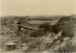
Archives - Bridge on Indus

sat_img
Indus as viewed from satellite

Indus Delta
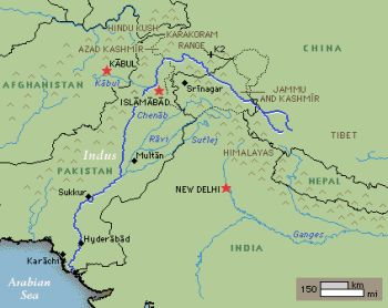
indus_map If there was no Indus river, there would not have no people living in this part of the world. Originating from the glacial Tibetan mountains, the Indus gushes in to Pakistan with all its might and fright from the northern areas. Near Attock, the River Kabul also joins this ferocious river and one can vividly see the blue Kabul River merging with the muddy Indus while standing on the bridge over Indus at Attock. Both join hands together and irrigate the entire length of Pakistan, approximately 2,900 km (1,800 mi), till it steadily calms down and fades away in the Arabia Sea.
Besides Indus, four other rivers also enter Pakistan from the neighbouring India, namely the Jhelub, Chenab, Ravi and Sutlej and all empty into the Indus to add to its might and power. The place where all these four rivers meet the Indus is known as "Panj Nadh (meaning in local language Five Rivers) south of the famous ancient city of Multan.
Having almost lost its impetus near the Arabia Sea, it fans out and forms the Indus Delta. Here the forests of mangroves and many a species of birds and fish flourish on the sweet waters of the Indus. The total area of the deltas that includes swamps and mangroves is approximately 225,000 hectares (556,000 acres). The port city of Karachi and marches of Ran of Kutch shoulder this delta during its final stages of journey. See More..

Cities that Indus Passes By: The Indus skirts and passes by the famous Attock, Bannu, Faisalabad, Multan, Khairpur, Sukkur, Larkana, Nawabshah, Mirpurkhas, Hyderabad  and finally embracing the Arabian Sea near the port city of Karachi (above).

The Indus Delta

The Indus Delta is the fifth largest delta in the world, characterized by high river discharge, moderate tides, and evidently the highest wave energy of any river in the world. The fan-shaped delta consists of creeks, estuaries, mud, sand, salt flats, mangrove habitat, marshes, sea bays, and straits and rocky shores. Its 129,000 ha. of mangrove, mostly Avicenna marina, comprises 97% of the total mangrove area in the country and is said to be the 7th largest mangrove forest in the world. The area is rich in archaeological and religious heritage.

The Indus River "Blind" Dolphin
dolphin1 dolphin2

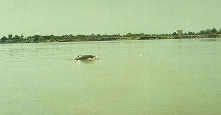
The Indus River harbours the rare species of nearly blind dolphin. The dolphin lacks eye lenses and the eye openings are no bigger than a pinhole. As a result, these rely almost entirely on echolocation to forage for food and navigate in the murky river waters.
The Indus Dolphin has a long beak, a small, low hump, wide flippers and an adult can weigh 70- 90 kg. They are slow swimmers, but can move in rapid spurts. They breathe through their slit - like blowholes with a loud sound that is similar to a sneeze, and can be heard from quite a distance." It sometimes carries its young on its back, above the surface of the water. These are found in a localized 100 mile stretch between the Sukkur and Guddu Barrages in Indus River. The dolphin, also known as Indus Susu, is one of the five species of cetaceans that are threatened with extinction, presently no more than 500 animals remaining. The Indus dolphin has been a victim of both deliberate and accidental exploitation. The Pakistan Adventure Foundation, a project funded by the UN Development Programme, is trying to create awareness about the endangered blind dolphin through rafting expeditions and visiting riverside fishing communities.

The Indus Dolphin is a "Living Fossil" that has not shared a common ancestor with any other living creature for around 25 million years ago. Read more...

River Jhelum (Urdu: جہلم) : Jhelum River is the largest and most western of the five rivers of Punjab, and passes through Jhelum District. It is a tributary of the Indus River. The valley of the Jhelum River, which includes the Vale of Kashmir, in the central portion; the mountains around Jammu in the south; and the great mountains of the Karakoram Range in the north. The Jhelum River rises in the north-eastern portion of the territory. It enters Pakistan near the Jhelum city and traverses down south to meet the Chenab River. The river was regarded as a god by the ancient Greeks, as were most mountains and streams; the poet Nonnus in the Dionysiaca (section 26, line 350) makes the Hydaspes a titan-descended god, the son of the sea-god Thaumas and the cloud-goddess Elektra. He was the brother of Iris the goddess of the rainbow, and half-brother to the harpies, the snatching winds. Since the river is in a country foreign to the ancient Greeks, it is not clear whether they named the river after the god, or whether the god Hydaspes was named after the river. Alexander the Great and his army crossed the Jhelum in 326 BC at the Battle of the Hydaspes where he defeated the Indian king, Porus. According to Arrian (Anabasis, 29), he built a city "on the spot whence he started to cross the river Hydaspes", which he named Bukephala (or Bucephala) to honour his famous horse Bukephalis which was buried in Jalalpur Sharif. It is thought that ancient Bukephala was near the site of modern Jhelum City. According to a historian of Gujrat district,Mansoor Behzad Butt, Bukephala was buried in Jalalpur Sharif, but the people of Mandi Bahauddin, a district close to Jehlum, believed that their tehsil Phalia was named after Bucephala, Alexander`s dead horse. They say that the name Phalia was the distortion of the word Bucephala.

The waters of the Jhelum are allocated to Pakistan under the terms of the Indus Waters Treaty. The Mangla Dam in Pakistan, the twelfth largest dam in the world, was built in 1967 on Jhelum River as part of the Indus Basin Water Treaty.

River Chenab: 960 km long Chenab River (Urdu: چناب‎') originates from the Himalayas in Himachal Pradesh State, India. Through the area of Jammu and Kashmir controlled by India, it takes a generally south-western direction through Punjab Province of Pakistan, forming the boundary between the Rechna and Jech interfluves (Doabs in Persian). It is joined by the Jhelum River at Trimmu, and then by the Ravi River. It then merges with the Sutlej River near Uch Sharif to form the Panjnad ('Five Rivers'), which joins the Indus at Mithankot. The total length of the Chenab is approximately 960 kilometres. The waters of the Chenab are allocated to Pakistan under the terms of the Indus Waters Treaty. Generally the most healthy river of Pakistan after Indus, it joins the generally dry Sutlej River and thence it joins Jhelum before falling in to the Indus.

The river was known to Indians in Vedic period as Ashkini or Iskmati and as Acesines to the Ancient Greeks. In 325 BC, Alexander the Great allegedly founded the town of Alexandria on the Indus (present day Uch Sharif or Mithankot or Chacharan) at the confluence of the Indus and the combined stream of Punjab rivers (currently known as the Panjnad River). The Chenab has the same place in the consciousness of the people of the Punjab, as, say the Rhine holds for the Germans, or the Danube for the Austrians and the Hungarians. It is the iconic river around which Punjabi consciousness revolves, and plays a prominent part in the tale of Heer Ranjha, the Punjabi national epic.

Boat bridge on Ravi near Lahore (1895)

River Ravi: The River Ravi (Urdu: راوی‎) originates from the Himalayas near Chamba in Himachal Pradesh State, northern India. The Ravi River  is a river in India and Pakistan. It is one of the five rivers which give Punjab its name. The Ravi was known as Parushani or Iravati to Indians in Vedic times and Hydraotes to the Ancient Greeks. The river flows west and then southwest in Punjab Province, Pakistan, for about 764 km (475 mi). Near Bahawalpur it joins the Chenab River. The river skirts the ancient and historic city of Lahore, Pakistan. On its western bank is located the famous tomb of Jahangir. It once flew near the Lahore Fort. It also once skirted the city of Multan, but then gradually drifted away.

River Sutlej: Sutlej River (Urdu: ستلج‎), is the longest of the five rivers that flow through Indian Punjab in northern India. Its source is in Tibet near Mount Kailash and its terminus in Pakistani Punjab. It is the easternmost affluent of the Punjab, and it receives the Beas River in the state of Punjab, India and continues into Pakistan to join the Chenab River to form the Panjnad River, which further down its course joins the Indus River at Mithankot. There is substantial evidence to indicate that prior to 1700 B.C. the Sutlej was once an important tributary of the Sarasvati River, instead of the Indus River. It is believed that tectonic activity created elevation changes that redirected the Sutlej from southeast to southwest. Once flowing in its new westward direction, the river eventually joined the Beas river. As a result, the mighty Sarasvati River began to dry up, causing the desertification of Cholistan and Sindh, as well as the abandonment of numerous ancient human settlements along its banks.


| HOME PAGE | MORE ABOUT OUR LAND |
This page was created on 1 January 2005 / 6 January 2009

Copyright©JalalsPages - 2005 -2009